Last weekend, we went away. I know. It seems almost unbelievably adventurous after having been confined to my weekly commute between Rotterdam and Zeeland for an entire year. Given that we are in lockdown, you might well wonder why we went at all. Well, there were three reasons: the first was that I'm doing research for a project I’m busy with and needed to go to there; the second was that my daughters had extolled the beauties of the area I needed to go to, this being south Limburg, and thirdly, I knew it would be very quiet and empty of people. The town we stayed in was Valkenburg, which most of the time exists for tourists. However, there are no tourists now so we could be assured of a peaceful time with virtually no one about.
South Limburg is the southernmost province of the Netherlands and is distinguished by having real hills of the rolling, gorgeous and unexpectedly scenic variety. I have to say this was a complete surprise to me because although I've been to Maastricht a few times, I've never explored the countryside to the east of the Maas river there. Mostly, when you speak to Dutch people, they will tell you the Netherlands is completely flat except for 'a couple of hills' in Limburg. I took them at their word and had no idea I would be driving through rural scenery that would equal the prettiness of England's Devon or Belgium's Wallonia. What a delight it was, and worth every metre of the additional 130 kms each way that we had to drive so as to avoid going through Belgium.
 |
The black line is the obvious route; the blue
line is (more or less) what we had to do |
From the crumbly cottage in Zeeland's southernmost point, the direct route to Limburg is straight across Belgium from Antwerp. However, Belgium is currently off-limits, so we had to drive north to Breda and then east to Eindhoven before going south to Maastricht. Valkenburg is to the east of Maastricht. This meant that instead of a 140 km drive, it was 270 kms – each way. We took it gently, though, and shared the driving. The weather was beautiful too, which was a blessing, and the whole trip was just the tonic I needed.
 |
| The Wilhelminatoren |
 |
| Valkenburg from the Wilhelminatoren |
Valkenburg was originally the stronghold of a family of the same name. It is the only castle in the Netherlands built on a hill (now there's a surprise, I hear you say), and even then is only on the foothill of the real thing, the top of which is where I took the photos above. The castle began life in the 12th century and went through several stages of building in the following centuries, mostly due to being sacked by marauding invaders and then rebuilt. However, its final demise as a complete fortification occurred in 1672, when the French King Louis the 14th conducted a long and devastating siege of Maastricht, using Valkenburg Castle as an outpost for fighting. Eventually William III of the Netherlands retaliated by destroying the castle to such a degree it would never be rebuilt. For the next few hundred years, the castle ruins were neglected, until in the early 20th century a foundation was set up to preserve them and keep them safe for future generations. I must admit I found it really impressive to look up at it from the city and to walk around its perimeter walls, but from the top of Heunsberg Hill, it looks positively small. The Wilhelminatoren, however, which you can see in the first photo, looks impressive from any angle. It is a much later addition. You can read about it
here with Google Translate's help :)
 |
| The castle looks impressive from the town |
 |
| Beautiful, but not Dutch as we know it |
 |
| The river Geul |
Valkenburg is a very pretty town, completely unlike anything you would expect in the Netherlands and with none of the influences that grace Amsterdam, Utrecht and all the other beautiful Dutch cities. It is very much its own place, as is Maastricht, and I had a powerful feeling of being in another country completely. What with the hills, the panoramic vistas, the limestone buildings and more Belgian or even French architecture, it was hard to believe we were still in the Netherlands.
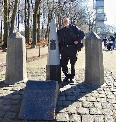
Our visit was a short one, but one thing we both wanted to do while we were there was visit the 'Drielandenpunt' some 22kms away. It's the point where Germany, Belgium and the Netherlands all come together at the top of the Vaalseberg, the highest point in the Netherlands and a hefty 322.5 metres above sea level. At this one point, you can straddle three countries without moving.
 |
Drielandenpunt. B is for Belgium. At the back it's Germany
and to the left is the Netherlands. |
 |
| A German barrel organist |
And as if to underscore its international flavour, the barrel organist above was German. I think he was actually standing in the Netherlands although I'm not completely sure, but that's the beauty of this place. It doesn't matter.
And for those who remember a post I did a while back about Belgium's border markers, this is number 1 that Koos is leaning against, the first in the series of 369 that were placed over a border length of 458kms. In fact, Koos marks the spot.
While I'm on the subject of superlatives, I'm sure readers here know by now that we cannot stay away from the water and boats for long, so on our way home we stopped at Maasbracht to look at the Netherland's deepest lock, which is found on the Juliana Canal that runs parallel to the Maas. I should say that most locks in the country reflect the flatness of the landscape and are rarely more than a couple of metres deep. The fall on this one is almost 12 metres, which is impressive by anyone's standards. We just struck lucky when we saw this container barge coming in and had to watch the whole process, of course.
 |
| The container barge arriving |
 |
| At the bottom |
 |
| Starting her exit |
 |
| Squeaking out under the road bridge |
 |
| And off she goes, south into Belgium |
Back home again, it's been a stormy week. The weather broke on Tuesday and by Thursday, the winds were howling. We had to go to Terneuzen, so we took a walk along the estuary of the Westerschelde. It's hard to tell from the photos below, but the wind was so strong I had trouble keeping to my feet. I think you can just see the white caps on the water.
The boats below were in the safety of the harbours. The blue one was dredging, which was interesting to watch. It doesn't matter what the weather's doing, work must go on!
It is odd to think we are now at the opposite end of the Nethelands. In fact, the last Belgian border marker (No. 369) isn't all too far from where we are now, and yet the country we are so close to is so far away at the moment. I do so hope we can cross that border again before too long. Belgium is very much a second home to me and I miss it.
Have a good weekend, allemaal.


